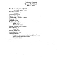
Churchville to Queensville (1977)
Item
-
Title
-
Churchville to Queensville (1977)
-
Description
-
Radar tops 18.3km (60,000ft). Tornado embedded in derecho. Golf ball size hail in Innisfil. Yellowish-orange clouds. Witnesses observed the tornado with apparent satellite vortex bobbing up and down to the side of parent vortex. Noted that a “plow wind†1mi wide was suspected from Cook Bay and south. Noted that it was miraculous that no one was hurt. *Sat. June 9, 1906 tornado in same area?* Witness noted that three other tornadoes occurred within the same decade around the Queensville area, and another one was mentioned to have occurred in 1964, 1 mi east of this tornado track. Track Length : UTM = 23.26km (14.45mi) Update sheet = 1.52km (0.94mi), Max Width : 50m (164ft) notes indicate about 200ft wide, Direction : UTM = 305° (NW-SE) Confirmation sheet = 290° (WNW-ESE), Damage Cost: N/A, likely >$10,000
-
Publisher
-
NTP Archives
-
Date
-
1977-07-15
-
Time (Local)
-
14:00
-
County
-
York
-
Province
-
Ontario
-
Country
-
Canada
-
Fujita Rating
-
F1
-
Classification
-
Confirmed
-
Track Length
-
23.26
-
Max Width
-
0.05
-
Direction
-
NW - SE
-
Shape
-
Large dark funnel with a smaller one (satellite) off to the side.
-
Damage Type
-
A garage was completely destroyed and a house’s roof was partially removed. Other moderate to minor damage occurred on properties. Missiles were generated and caused secondary damage. Large objects were moved. Fences downed. Trees, some large (3ft DBH) were uprooted.