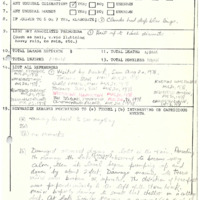
Lefroy to Little Cedar Point (1978)
Item
-
Title
-
Lefroy to Little Cedar Point (1978)
-
Description
-
Noted that clouds had a deep blue tinge and hail up to 1in in diameter fell. Damage occurred during a lull in the rain. Preceding the damage the lake became very calm and then began to “pump†up and down by about 2 feet. Direction of tree fall was perpendicular to the left of storm track. All indicative of probable tornado. Track Length : Approx. 2.41km (1.5mi), Direction : Approx. 225° (SW-NE), Damage Cost: N/A, likely <$5,000
-
Publisher
-
NTP Archives
-
Date
-
1978-08-19
-
Time (Local)
-
16:30
-
County
-
Simcoe
-
Province
-
Ontario
-
Country
-
Canada
-
Fujita Rating
-
F0
-
Classification
-
Probable
-
Track Length
-
2.41
-
Max Width
-
0.152
-
Direction
-
SW - NE
-
Damage Type
-
Minor damage occurred to boat shelters and docks, a cottage boat house, and trees in the area.